LOCATION.--Lat 40°41'38", long
73°53'51" referenced to North American Datum of 1927,
Queens County, NY, Hydrologic Unit 02030201, at north side of
Cabot Road, 66 ft west of Cypress Avenue, easternmost well,
Ridgewood.
WELL CHARACTERISTICS.--Depth 110 ft. Upper casing
diameter 2 in; top of first opening 100 ft, bottom of last
opening 105 ft.
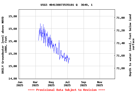
DATUM.--Land-surface datum is 88.4 ft above National
Geodetic Vertical Datum of 1929. Measuring point: Top of
casing, 0.28 ft below land-surface datum, 88.12 ft above
land-surface datum, Jul. 26, 1996 to present.
PERIOD OF RECORD.--April 1993 to April 2013, May 2024 to
current year.
GAGE.--Periodic manual measurements by USGS
personnel.
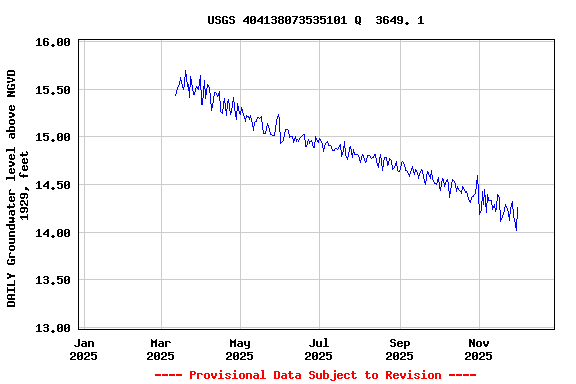
EXTREMES FOR PERIOD OF RECORD.--Highest water level
measured, 15.93 ft above NGVD of 1929, Feb. 29, 2012; lowest
measured, 11.30 ft above NGVD of 1929, Aug. 28, 2002.
 Site Information
 WaterAlert – get an
email or text (SMS) alert based on your chosen threshold.
WaterAlert – get an
email or text (SMS) alert based on your chosen threshold. Station image