LOCATION.--Lat 40°45'38.6", long
73°46'50.3" referenced to North American Datum of
1983, Queens County, NY, Hydrologic Unit 02030201, at west side
of 204th Street, 99 ft north of 42nd Avenue, Auburndale.
WELL CHARACTERISTICS.--Depth 80 ft. Upper casing
diameter 2 in; top of first opening 70 ft, bottom of last
opening 80 ft.
DATUM.--Land-surface datum is 84 ft above National
Geodetic Vertical Datum of 1929. Measuring point: Top of
casing, 0.14 ft below land-surface datum, 83.86 ft above
land-surface datum, Jun. 25, 1998 to present.
PERIOD OF RECORD.--July 1998 to April 2015, May 2024 to
current year.
GAGE.--Periodic manual measurements by USGS
personnel.
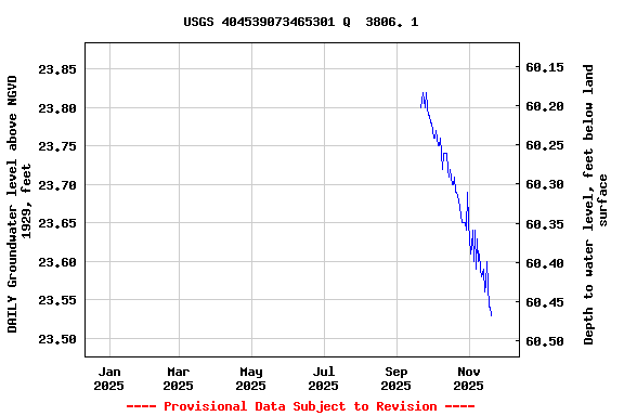
EXTREMES FOR PERIOD OF RECORD.--Highest water level
measured, 26.32 ft above NGVD of 1929, June 15, 2010; lowest
measured, 21.27 ft above NGVD of 1929, Apr. 18, 2000.
 Site Information
 WaterAlert – get an
email or text (SMS) alert based on your chosen threshold.
WaterAlert – get an
email or text (SMS) alert based on your chosen threshold. Station image