LOCATION.--Lat 40°48'18", long
73°29'31" referenced to North American Datum of 1927,
Nassau County, NY, Hydrologic Unit 02030202, at west side of
Park Drive East, just south of Debra Place, in recharge basin
#427, Locust Grove.
WELL CHARACTERISTICS.--Depth 595 ft. Upper casing
diameter 4 in; top of first opening 570 ft, bottom of last
opening 590 ft.
DATUM.--Land-surface datum is 207.5 ft above National
Geodetic Vertical Datum of 1929. Measuring point: Top of 4 inch
steel casing, north edge, 207.54 ft above National Geodetic
Vertical Datum of 1929, Jul. 20, 1990 to Oct. 6, 2023; Top of 4
inch steel casing, north edge, 207.5 ft above National Geodetic
Vertical Datum of 1929, Oct. 6, 2023 to present.
PERIOD OF RECORD.--March 1991 to current year.
GAGE.--Water-level recorder installed August 2002;
15-minute recording interval. Periodic manual measurements made
by USGS personnel.
REMARKS.--Cellular water-level telemeter at
station.
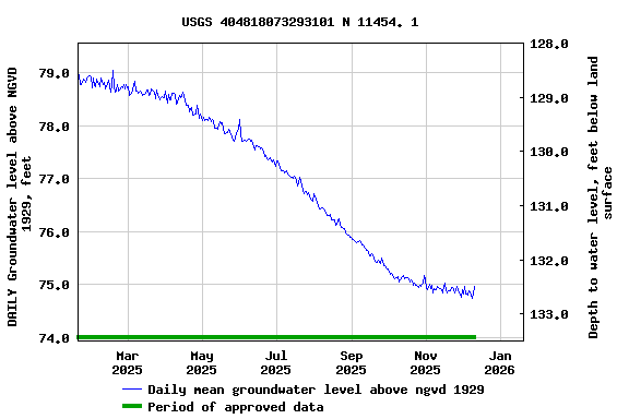
EXTREMES FOR PERIOD OF RECORD.--Highest water level
measured, 82.51 ft above NGVD of 1929, Mar. 20, 1991; lowest
recorded, 69.56 ft above NGVD of 1929, Oct. 8, 2002.
 Site Information
 WaterAlert – get an
email or text (SMS) alert based on your chosen threshold.
WaterAlert – get an
email or text (SMS) alert based on your chosen threshold.