LOCATION.--Lat 40°49'26.1", long
73°40'52.9" referenced to North American Datum of
1983, Nassau County, NY, Hydrologic Unit 02030201, at south
side of Revere Road, just east of Port Washington Boulevard,
Port Washington.
WELL CHARACTERISTICS.--Depth 120 ft. Upper casing
diameter 2 in; top of first opening 95 ft, bottom of last
opening 115 ft.
DATUM.--Land-surface datum is 154 ft above National
Geodetic Vertical Datum of 1929. Measuring point: Top of
casing, 0.45 ft below land-surface datum, 153.55 ft above
National Geodetic Vertical Datum of 1929, Mar. 31, 1994 to Dec.
9, 2011; North side of PVC casing, 0.4 ft below land surface
datum, 152.0 ft above North American Vertical Datum of 1988,
Dec. 9, 2011 to present.
PERIOD OF RECORD.--March 1994 to March 1998, January
2002 to current year.
GAGE.--Periodic manual measurements by USGS
personnel.
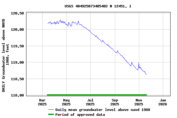
EXTREMES FOR PERIOD OF RECORD.--Highest water level
measured, 125.74 ft above NGVD of 1929, Apr. 17, 2024; lowest
measured, 118.08 ft above NGVD of 1929, Dec. 5, 1995.
 Site Information
 WaterAlert – get an
email or text (SMS) alert based on your chosen threshold.
WaterAlert – get an
email or text (SMS) alert based on your chosen threshold. Station image