LOCATION.--Lat 40°50'12.0", long
73°29'34.6" referenced to North American Datum of
1983, Nassau County, NY, Hydrologic Unit 02030202, at Nassau
County Recharge Basin #531, 87 ft south of Foxhunt Crescent
South Road, southernmost well, Oyster Bay Cove.
WELL CHARACTERISTICS.--Depth 535 ft. Upper casing
diameter 4 in; top of first opening 500 ft, bottom of last
opening 525 ft.
DATUM.--Land-surface datum is 209 ft above National
Geodetic Vertical Datum of 1929. Measuring point: Top of
casing, 0.12 ft below land-surface datum, 208.88 ft above
National Geodetic Vertical Datum of 1929, Feb. 6, 1992 to
present.
PERIOD OF RECORD.--February 1992 to September 1997,
January 2006 to current year.
GAGE.--Periodic manual measurements by USGS
personnel.
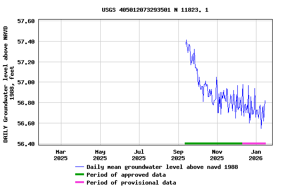
EXTREMES FOR PERIOD OF RECORD.--Highest water level
measured, 63.23 ft above NGVD of 1929, May 16, 2007; lowest
measured, 53.96 ft above NGVD of 1929, Aug. 28, 2018.
 Site Information
 WaterAlert – get an
email or text (SMS) alert based on your chosen threshold.
WaterAlert – get an
email or text (SMS) alert based on your chosen threshold. Station image