LOCATION.--Lat 40°50'35.92", long
72°39'02.21" referenced to North American Datum of
1983, Suffolk County, NY, Hydrologic Unit 02030202, at south
side of Stewart Avenue, 0.25 mi west of Old Riverhead Road at
telephone pole #79 on north side of road, 27 ft south of road
center, West Hampton.
WELL CHARACTERISTICS.--Depth 65 ft. Upper casing
diameter 2 in; top of first opening 55 ft, bottom of last
opening 60 ft.
PERIOD OF RECORD.--October 2023 to current year.
GAGE.--Water-level recorder installed October 2023;
15-minute recording interval. Cellular telemetry installed
October 2023. Periodic manual measurements made by USGS
personnel.
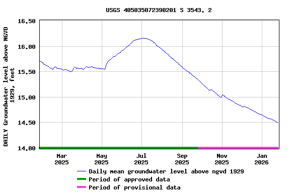
EXTREMES FOR PERIOD OF RECORD.--Highest water level
recorded, 18.21 ft above NGVD 1929, May 28, 2024; lowest
recorded, 14.91 ft above NGVD of 1929, Jan. 8, 2024.
 Site Information
 WaterAlert – get an
email or text (SMS) alert based on your chosen threshold.
WaterAlert – get an
email or text (SMS) alert based on your chosen threshold. Station image