| USGS
Climate-Response Network (CRN) Well WLN03 |
| County: |
Douglas |
| Township: |
Belle River (T129N R36W) |
| Location: |
1.1 miles east of the intersection of Co. Rd. 13 and Co. Rd.
3 |
| Land-surface elevation: |
1347.56 +/- 0.03 feet, NAVD88 |
| Installation: |
Nov. 4, 2004, for the Minnesota Department of Natural
Resources |
| |
|
| Well
information |
| Depth: |
20.35 feet |
| Open interval: |
11–21 feet |
| Original and current use: |
Monitoring, for the USGS National Groundwater and Streamflow
Information Program and the Minnesota Department of Natural
Resources' Cooperative Groundwater Monitoring (CGM)
Program. |
| |
|
| Aquifer
information |
| Type: |
Surficial sand and gravel |
| Thickness: |
More than 21 feet (0–>21 feet, BLS) |
| Deposit: |
Glacially deposited sand and gravel outwash |
 This site is monitored as part of the
USGS National Groundwater and Streamflow Information Program.
This site is also monitored as part of the Minnesota Department of
Natural Resources' Cooperative Groundwater Monitoring (CGM)
Program.
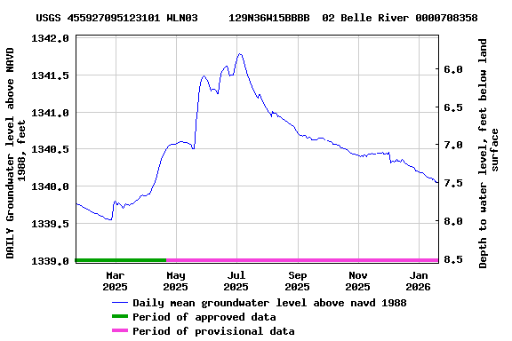
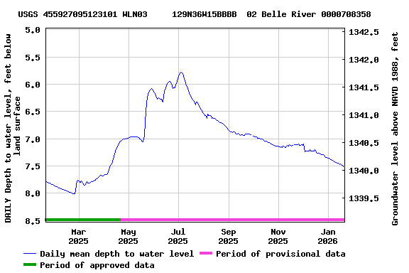
Water levels below land surface are accurate to 0.01 feet. Water
levels above North American Vertical Datum of 1988 (sea level) are
calculated by subtracting recorded water levels from the land surface
elevation, which is accurate to 0.03 feet based on a differential GPS
survey. Water-level differences are accurate to within 0.01 feet.
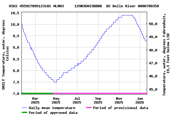
Water temperature is accurate to plus-or-minus 0.1°C, and
differences in temperature are accurate to 0.1°C.
Precipitation is accurate to 0.01 inches except during freezing
periods (about Dec. through early Apr.). The rain gage is unheated and
uncovered. The precipitation data during freezing periods result from
melting of snow (accumulated in the rain gage) during warm periods and
do NOT represent actual precipitation. Precipitation totals during
freezing periods may underestimate actual totals because the rain gage
funnel may be full of snow (preventing further accumulation) or because
snow in the funnel may sublimate instead of melt.
 This site is monitored as part of the
![Graph of DAILY Precipitation, total, inches, [not accurate when freezing]](https://natwebvaww01.er.usgs.gov/nwisweb/data/img/USGS.455927095123101.327379_73970.00045.00001_00006.20250120.20260120..0..gif)

