Funding for this site is provided by:
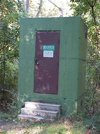
 STATION.
--01473169 VALLEY CREEK AT PENNSYLVANIA
TURNPIKE BRIDGE NEAR VALLEY FORGE, PA
LOCATION.--Lat 40`04'45", long
75`27'40", Chester County, Hydrologic Unit 02040203, on right
bank 100 ft upstream from Pennsylvania turnpike bridge, 0.9 mi
downstream from Little Valley Creek, and near Valley Forge.
DRAINAGE AREA.--20.8 square miles.
PERIOD OF RECORD.--October 1982 to current year.
GAGE.--Water-stage recorder, water-quality monitor and
Pluvio precipitation gage. Satellite telemetry at station. Datum of
gage is 108.62 ft above National Geodetic Vertical Datum of 1929.
COOPERATION.--Funding for the operation of this
station provided by Chester County Water Resources Authority, the U.S.
National Park Service, and the U.S. Geological Survey.
REMARKS.--Intermittent pumpage from quarry
upstream.
GAGE HEIGHTS OF IMPORTANCE.-
Supplied by USGS: Maximum recordable gage height
(stage sensor operational limit) - 24.2 ft; Data transmitter
operational limit - 24.8 ft;
Supplied by NWS: No flood stage has been determined
for this station.
 STATION.--01473169 VALLEY CREEK AT PENNSYLVANIA
TURNPIKE BRIDGE NEAR VALLEY FORGE, PA


