Warning: Javascript must be enabled to use all the features on this page!


Page Loading - Please Wait...

Click to hideNews Bulletins
! This page is undergoing modernization with expected decommissioning as key features are added to the modernized pages.
Learn more about our modernization plans to find out which options will suit you best. Next Generation Monitoring Location Page is available now.

USGS 03030500 Clarion River near Piney, PA

PROVISIONAL DATA SUBJECT TO REVISION

Click to hidestation-specific text
Funding for this site is provided by:
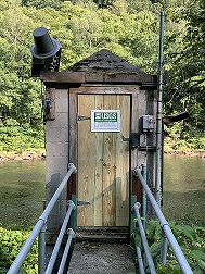


Station gage imageSTATION.--03030500 CLARION RIVER NEAR PINEY, PA
LOCATION.--Lat 41`11'33", long 79`26'25", Clarion County, Hydrologic Unit 05010005, on left bank 0.2 mi downstream from hydroelectric plant of Pennsylvania Electric Co., 2.3 mi northeast of Piney, 2.4 mi upstream from Piney Creek, and 3 mi southwest of Clarion.
DRAINAGE AREA.--951 square miles.
PERIOD OF RECORD.--October 1944 to current year (monthly discharge only October 1944 to September 1947).
GAGE.--Water-stage recorder and crest-stage gage. Datum of gage is 1,001.5 ft above North American Vertical Datum of 1988. Prior to April 5, 2023, the datum of gage was reported as 1,002.06 ft above National Geodetic Vertical Datum of 1929 (Pennsylvania Electric Co. bench mark). Prior to Dec. 23, 1947, records from hydroelectric plant 0.2 mi upstream.
COOPERATION.--Station established and maintained by the U.S. Geological Survey in cooperation with Brookfield Power.
REMARKS.--Flow regulated by East Branch Clarion River Lake since June 1952 and by hydroelectric plant at Piney Dam 0.2 mi upstream since 1924, combined capacity of reservoirs, 113,200 acre-ft. U.S. Army Corps of Engineers satellite telemeter at station.
This station managed by the PAWSC Pittsburgh Field Office.

Available Parameters Available Period
  
1991-10-01  2024-06-29
2007-10-01  2024-06-29
2022-01-01  2024-06-29


 (7)
 

  -- or --


Summary of all available data for this site
Instantaneous-data availability statement


Discharge, cubic feet per second

Most recent instantaneous value: 691 06-29-2024   11:45 EDT
Graph of  Discharge, cubic feet per second

Add up to 2 more sites and replot for "Discharge, cubic feet per second"

?


Create presentation-quality / stand-alone graph.   Subscribe to WaterAlert      

See this graph on the Monitoring Location Pages


Daily discharge, cubic feet per second -- statistics for Jun 29 based on 76 water years of record more
Min
(1963)
25th
percen-
tile
Most Recent
Instantaneous
Value Jun 29
Median 75th
percen-
tile
Mean Max
(1983)
21.0 410 691 724 1200 1520 31400


Gage height, feet, [Primary]

Most recent instantaneous value: 3.34 06-29-2024   11:45 EDT
Graph of  Gage height, feet, [Primary]

Add up to 2 more sites and replot for "Gage height, feet, [Primary]"

?


Create presentation-quality / stand-alone graph.   Subscribe to WaterAlert      

See this graph on the Monitoring Location Pages


Stream water level elevation above NAVD 1988, in feet

Most recent instantaneous value: 1004.84 06-29-2024   11:45 EDT
Graph of  Stream water level elevation above NAVD 1988, in feet

Add up to 2 more sites and replot for "Stream water level elevation above NAVD 1988, in feet"

?


Create presentation-quality / stand-alone graph.   Subscribe to WaterAlert      

See this graph on the Monitoring Location Pages