LOCATION.--Lat 41°43'18", long
73°56'28" referenced to North American Datum of 1927,
Dutchess County, NY, Hydrologic Unit 02020008, on left bank at
city pumping station, adjacent to Marist College, 0.5 mi north
of Poughkeepsie, and 1.3 mi upstream from Mid-Hudson
bridge.
DRAINAGE AREA.--11,833 mi².
PERIOD OF RECORD.--October 2012 to current year.
REVISIONS HISTORY.--Drainage area was revised on Aug.
30, 2023, from 11,700 sq mi to 11,833 sq mi, based on better
definition methods.
GAGE.--Water-stage recorder. Datum of gage is NGVD of
1929. To convert elevations to NAVD of 1988, subtract 0.86
ft.
REMARKS.--Elevations are not corrected for changes in
water density. Blanks in tables are the result of only one high
or low tide during a day or interruption of record.
EXTREMES FOR PERIOD OF RECORD.--Maximum elevation, 9.91
ft, Oct. 30, 2012; minimum elevation, about -3.90 ft, Jan. 6,
2018.
PERIOD OF RECORD1.--
CHEMICAL DATA: 1969 (c), 1970-71 (d), 1972 (b), 1973 (e),
1974-75 (d), 1988 (a), 1989-90 (b), 1991 (c), 1992 (a), 1993
(c),
1994 (d), 1995 (c), 1996 (a), 2010-13 (d).
MINOR ELEMENTS DATA: 1969 (c), 1970-71 (d), 1972 (b), 1973-75
(d), 1988 (a), 1989-90 (b), 1991 (c), 1992 (a).
RADIOCHEMICAL DATA: 1974 (a), 1975 (d).
PESTICIDE DATA: 1993-94, 1996 (a), 2010-13 (d).
ORGANIC DATA: OC--1974 (b), 1975 (d), 1993 (c), 1994 (d), 1995
(c), 1999-2000 (e), 2010-13 (d). PCB--1993 (a). PCN--1993
(a).
NUTRIENT DATA: 1969 (c), 1970-71 (d), 1972 (b), 1973-75 (d),
1993 (c), 1994 (d), 1995 (c), 2010-13 (d).
BIOLOGICAL DATA: Bacteria--1973 (c), 1974-75 (d).
Phytoplankton--1973 (a), 1974 (b), 1975 (d), 1993 (a).
Periphyton--1974 (c), 1975 (a).
SEDIMENT DATA: 1973 (a), 1974 (b), 1975 (a), 1989-90 (b), 1991
(c), 1992 (a), 1993 (c), 1994 (d), 1995 (c), 1999-2000 (e),
2010 (e), 2011-13 (d).
October 1959 to September 1966, October 1972 to September
1975, April 2019 to current year.
PERIOD OF DAILY RECORD1.--WATER TEMPERATURE:
October 1959 to September 1966, October 1972 to September
1975. WATER TEMPERATURE [HRECOS] AT PUMP: November 2019
to January 2021. WATER TEMPERATURE [HRECOS] AT SURFACE: April
2019 to current year.
SPECIFIC CONDUCTANCE [HRECOS] AT PUMP: November 2019 to January
2021. SPECIFIC CONDUCTANCE [HRECOS] AT SURFACE: April 2019 to
current year.
pH [HRECOS] AT PUMP: November 2019 to January 2021. pH [HRECOS]
AT SURFACE: April 2019 to current year.
DISSOLVED OXYGEN [HRECOS] AT SURFACE: April 2019 to current
year.
TURBIDITY [HRECOS] AT PUMP: November 2019 to January 2021.
TURBIDITY [HRECOS] AT SURFACE: April 2019 to current
year.
INSTRUMENTATION1.--[HRECOS] AT PUMP: A
multi-parameter water-quality sonde measures water temperature,
specific conductance, pH, and turbidity at 15-minute intervals
from November 2019 to January 2021.
[HRECOS] AT SURFACE: A multi-parameter water-quality sonde
measures water temperature, specific conductance, pH, dissolved
oxygen, and turbidity at 15-minute intervals since April
2019.
REMARKS1.--Daily water-temperature
measurements were made at approximately 0830 during water years
1960-63 and at approximately 0700 during water years
1964-66. Daily water-temperature measurements were made
between 0800 and 0830 during water years 1973-75, furnished by
City of Poughkeepsie, Water Department. Temperature
readings during water years 1960-63, 1973-75 were originally
published rounded to the nearest 0.5°C.
COOPERATION1.--April 2019 to current year:
Maintained by the Hudson River Environmental Conditions
Observing System in cooperation with Marist College and
the Cary Institute of Ecosystem Studies.
EXTREMES FOR PERIOD OF DAILY RECORD1.--WATER
TEMPERATURE (water years 1960-66, 1973-75): Maximum daily,
27.0°C, Aug. 5, 1975; minimum daily, 0.0°C, Dec. 26-28, 1974.
WATER TEMPERATURE [HRECOS] AT PUMP: Maximum, 30.0°C, Aug. 11,
2020; minimum, 1.6°C, on several days during winter periods.
WATER TEMPERATURE [HRECOS] AT SURFACE: Maximum, 28.0°C, on
several days during summer 2019 period; minimum -0.1°C, on many
days during 2021 winter period.
SPECIFIC CONDUCTANCE [HRECOS] AT PUMP: Maximum, 1,220 uS/cm @
25°C, Sept. 30, 2020, minimum, 112 uS/cm @ 25°C, Nov. 6, 2019.
SPECIFIC CONDUCTANCE [HRECOS] AT SURFACE: Maximum, 454 uS/cm @
25°C, Mar. 5, 2021; minimum, 153 uS/cm @ 25°C, Apr. 28, 29,
2019.
pH [HRECOS] AT PUMP: Maximum, 8.3, on several days in Jan.
2021; minimum, 6.6, on several days in June and July 2020. pH
[HRECOS] AT SURFACE: Maximum, 8.6, May 25, 2019; minimum, 7.0,
July 29, 30, 31, 2019.
DISSOLVED OXYGEN [HRECOS] AT SURFACE: Maximum, 15.1mg/L, Dec.
31, 2019, January 1, 2020, Jan. 29, 2021; minimum, 3.9 mg/L,
July 27, 2019.
TURBIDITY [HRECOS] AT PUMP: Maximum, 21.7 FNU, Nov. 12, Dec.
16, 2020; minimum, <0.3 FNU, Jan. 22, 2021. [<, actual
value is known to be less than the value shown].
1 Water-Quality Records
 Site Information
 WaterAlert – get an
email or text (SMS) alert based on your chosen threshold.
WaterAlert – get an
email or text (SMS) alert based on your chosen threshold.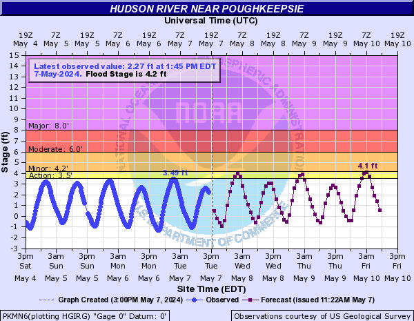
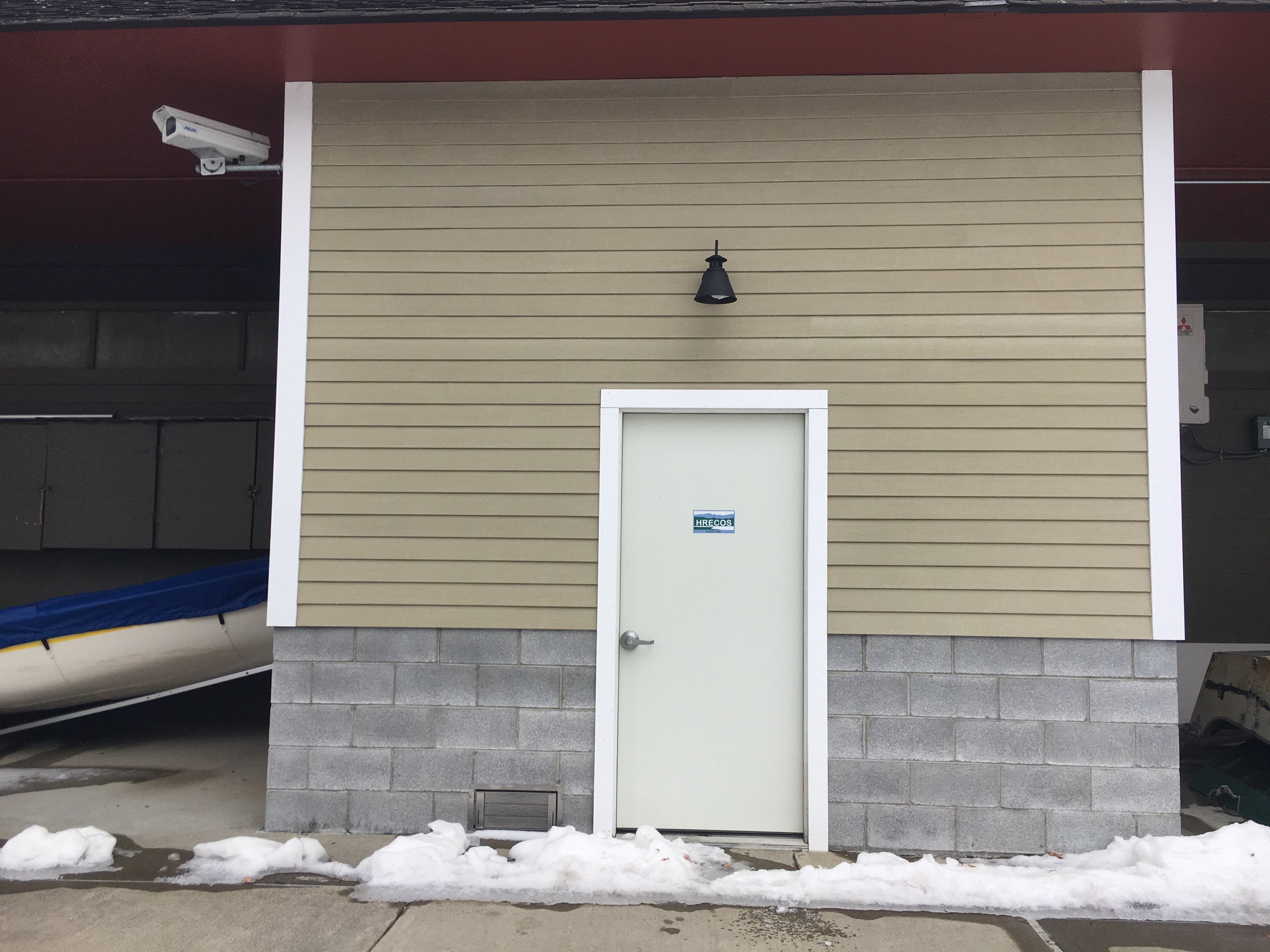 Station image


![Graph of Salinity, water, unfiltered, practical salinity units at 25 degrees Celsius, [HRECOS (near surface)]](https://natwebvaww01.er.usgs.gov/nwisweb/data/img/USGS.01372043.291476.90860..20241101.20241108..0..gif)