Warning: Javascript must be enabled to use all the features on this page!


Page Loading - Please Wait...

Click to hideNews Bulletins
! This page is undergoing modernization with expected decommissioning as key features are added to the modernized pages.
Learn more about our modernization plans to find out which options will suit you best. Next Generation Monitoring Location Page is available now.
A beta version of the My Favorites page is available in WDFN. Try it out and tell us what you think at wdfn@usgs.gov

USGS 02322700 ICHETUCKNEE R @ HWY27 NR HILDRETH, FL

PROVISIONAL DATA SUBJECT TO REVISION

Click to hidestation-specific text

This gage is monitored in cooperation with the Florida Department of Environmental Protection.

Link to the Florida Department of Environmental Protection.


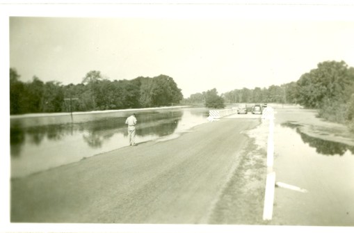
High water on April 10, 1948.

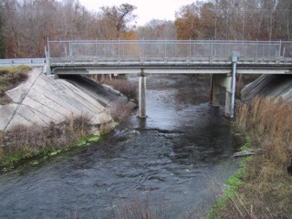
Gage structure on January 3, 2002.
Available Parameters Available Period
  
2017-01-18  2026-10-15
2002-02-05  2026-10-15
2007-10-01  2026-10-15
2017-01-18  2026-10-15
2022-01-20  2026-10-15
2022-01-20  2025-12-02
2026-06-17  2026-10-15
2016-11-15  2025-07-14


 (7)
 

  -- or --


Summary of all available data for this site
Instantaneous-data availability statement

Most recent instantaneous value: 23.1 10-15-2026   18:45 EDT
Graph of

Add up to 2 more sites and replot for "Temperature, water, degrees Celsius"

?


Create presentation-quality / stand-alone graph.   Subscribe to WaterAlert      

See this graph on the Monitoring Location Pages


Most recent instantaneous value: 218 10-15-2026   18:45 EDT
Graph of

Add up to 2 more sites and replot for "Discharge, cubic feet per second"

?


Create presentation-quality / stand-alone graph.   Subscribe to WaterAlert      

See this graph on the Monitoring Location Pages


Daily discharge, cubic feet per second -- statistics for Oct 15 based on 24 water years of record more
Min
(2005)
Most Recent
Instantaneous
Value Oct 15
25th
percen-
tile
Median Mean 75th
percen-
tile
Max
(2006)
174 218 259 309 310 358 434

Most recent instantaneous value: 14.86 10-15-2026   18:45 EDT
Graph of

Add up to 2 more sites and replot for "Gage height, feet"

?


Create presentation-quality / stand-alone graph.   Subscribe to WaterAlert      

See this graph on the Monitoring Location Pages


Most recent instantaneous value: 274 10-15-2026   18:45 EDT
Graph of

Add up to 2 more sites and replot for "Specific conductance, water, unfiltered, microsiemens per centimeter at 25 degrees Celsius"

?


Create presentation-quality / stand-alone graph.   Subscribe to WaterAlert      

See this graph on the Monitoring Location Pages


Most recent instantaneous value: 5.8 10-15-2026   18:45 EDT
Graph of

Add up to 2 more sites and replot for "Dissolved oxygen, water, unfiltered, milligrams per liter"

?


Create presentation-quality / stand-alone graph.   Subscribe to WaterAlert      

See this graph on the Monitoring Location Pages


pH, water, unfiltered, field, standard units
 
-- Data temporarily unavailable for the time period specified --

Most recent instantaneous value: 2.49 10-15-2026   18:45 EDT
Graph of

Add up to 2 more sites and replot for "Mean water velocity for discharge computation, feet per second"

?


Create presentation-quality / stand-alone graph.   Subscribe to WaterAlert      

See this graph on the Monitoring Location Pages


Nitrate plus nitrite, water, in situ, milligrams per liter as nitrogen
 
-- Data temporarily unavailable for the time period specified --